

Chittagong Sea Port, Outer Port Limit & Weather Conditions
Chittagong is considered as the prime maritime port of Bangladesh. Chittagong is also a commercial city of Bangladesh
BANGLADESH COVERS AN AREA OF
147,570 sq km, a little more than the size of Greece. It extends from 20°34N to 26°38N latitude and from 88°01E to 92°41E longitude. Maximum extension is about 440 km in the E-W direction and 760 km in the
Anchorage A: the northernmost anchorage for vessels of more than 10 meters draught.
Anchorage B: in between anchorage “A” and “c”, for vessel’s scheduled to enter the
Anchorage C: the southernmost anchorage for lightering vessels and other not scheduled to enter within 24 hours.
DRAUGHT LIMIT
From Anchorage to Jetty Berth need approx 2 hours duly compulsory piloting by Port Pilot. Vessels drawing a draught of fewer than 8.5 m usually approaches to Chittagong outer anchorage directly at any time. Vessels drawing draught between 8.5m to 9.5m also approach to the outer anchorage directly depending on the time of arrival and height of the tide. However, vessels drawing draught over 9.5
m usually wait for the rising tide to approach Chittagong outer anchorage if arrives in the falling tide.
DENSITY OF WATER
The density of water varies at each turn of the tide which is semi-diurnal with prominent diurnal effect. It is therefore advisable that the masters check. That density of water at the CPA outer anchorage.
Specialized Services for ship owners, charterers & managers
Cargo discharge supervision and Live Reporting
Ship spares inspection, export, and customs clearance
WEATHER CONDITION
The weather in Bangladesh is largely governed by the monsoon. The prevailing wind directions are from south to southeast during the month of April
through September. After taking easterly direction for a while, The wind turns to the northerly and northeasterly directions, The latter prevails from November to January. During the month of February and March, winds turn via westerly direction back to the transition periods between monsoon and season in May, October and November, extreme of inclement weather like cyclones often occur with wind velocity in excess
of 30 knots. The waves are generally low showing distinct relation with the wind. The waves period vary between 3-4 seconds of waves of about 0.5 meters and about 6 seconds for waves of 2 meters.
During the months May to October, freshets are expected. Freshets are caused by the normal velocity of flow of EBB tide augmented by
expected when rainfall intensity reaches 200 mm in 24 hours.
Free Consultation.
Get In Touch .
Phone:
+88-01824923983
Email:
info@panoceanbd.com
Skype
ctgshipping
Chattogram
Port Limit
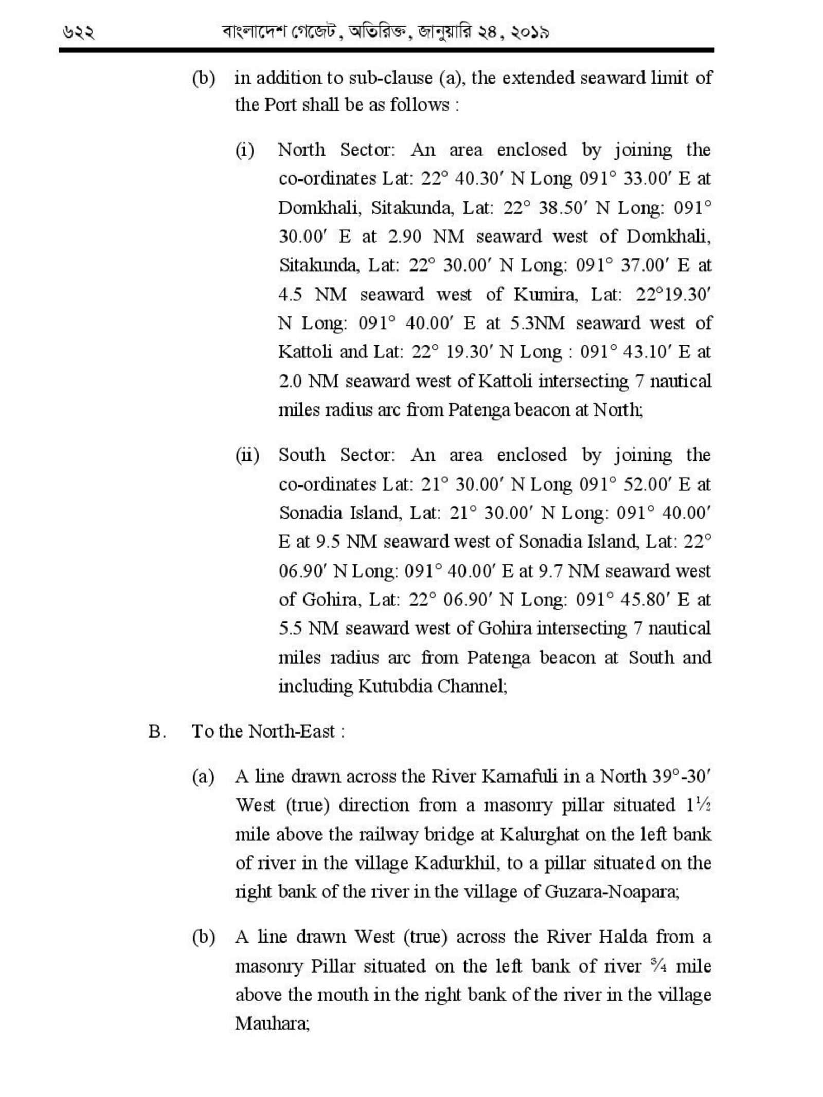
A. To the Sea :
(a) The entrance to the river with Patenga Beacon as centre if an arc is drawn seaward with a radius of 7 nautical miles till intersects the Coastline in Position Lat : 22° 20.4′ N Long : 091° 45.4′ E in the North and Lat : 22°7′ N Long : 091°50.5′E in the South, the area enclosed within the extremities of the arc;
(b) in addition to sub-clause (a), the extended seaward limit of the Port shall be as follows :
(i) North Sector: An area enclosed by joining the co-ordinates Lat: 22° 40.30′ N Long 091° 33.00′ E at Domkhali, Sitakunda, Lat: 22° 38.50′ N Long: 091° 30.00′ E at 2.90 NM seaward west of Domkhali, Sitakunda, Lat: 22° 30.00′ N Long: 091° 37.00′ E at 4.5 NM seaward west of Kumira, Lat: 22°19.30′ N Long: 091° 40.00′ E at 5.3NM seaward west of Kattoli and Lat: 22° 19.30′ N Long : 091° 43.10′ E at 2.0 NM seaward west of Kattoli intersecting 7 nautical miles radius arc from Patenga beacon at North;
(ii) South Sector: An area enclosed by joining the co-ordinates Lat: 21° 30.00′ N Long 091° 52.00′ E at Sonadia Island, Lat: 21° 30.00′ N Long: 091° 40.00′ E at 9.5 NM seaward west of Sonadia Island, Lat: 22° 06.90′ N Long: 091° 40.00′ E at 9.7 NM seaward west of Gohira, Lat: 22° 06.90′ N Long: 091° 45.80′ E at 5.5 NM seaward west of Gohira intersecting 7 nautical miles radius arc from Patenga beacon at South and including Kutubdia Channel;
B. (a) A line drawn across the River Karnafuli in a North 39°-30′ West (true) direction from a masonry pillar situated 1½ mile above the railway bridge at Kalurghat on the left bank of river in the village Kadurkhil, to a pillar situated on the right bank of the river in the village of Guzara-Noapara;
(b) A line drawn West (true) across the River Halda from a masonry Pillar situated on the left bank of river ¾ mile above the mouth in the right bank of the river in the village Mauhara;
C. To the North :
A line drawn West (true) to a distance of 1/10th miles towards land from the boundary Pillar whose latitude is 22°-15′-28″ North and longitude is 91°-46′-49″ East, in the village Patenga;
D. To the South :
A line drawn West (true) to a distance of 1/10 miles towards land from the boundary Pillar whose latitude is 22°-9′-5″ North and Longitude 91°-49′-29″ East, in the village Pourgapara.
2. These limits include so much of the River Karnafuli, the shore thereof as lie within 50 yards of high water mark at ordinary spring tides.
3. These limits also include docks, wharves, quays, stages, jetties, piers, ware-houses, sheds, railway line and yards within the limits of the boundary area and such area outside it as shown by boundary piliars on Plan No. 50 of the Port Commissioners.
Circulars : Chattogram Port Authority Circular. by Ministry of Shipping dated 21st Jan 2019

LIGHTERING OF CARGO AT CHITTAGONG ANCHORAGE AT MONSOON SEASON
Panocean pleased to update on STS operation. Lightening of cargo at Chittagong outer anchorage becomes relatively more difficult with the onset of monsoon and the period from May to October is considered as the monsoon. At any time within this period, rough sea and inclement weather is a common feature of the weather condition and often the weather condition deteriorates so abruptly that incidents, such as the one under consideration, becomes unavoidable. During this period, lighter vessels fastened alongside mother vessel experience heavy rolling and pitching often causing hard scarping, bendings and indentations to the mother vessels railing and hull. This is despite the fact that generally, the lighter vessel has fendering arrangements consisting of old mooring ropes wrapped around wooden spars often used or second-hand tires from automobiles are also used as fenders. Insofar as damages to mother vessel are concerned, top shell plate of the forecastle deck, bulwark gunwale, bulkhead (Both port and STBD side), brackets underneath and horizontal to gunwale and the hull, in general, are the areas of the mother vessel prone to contact damages caused by lighters situation worsens often because of the fact that generally the lighter vessel do not have winches fore and aft in order to heave up berthing ropes quickly. It is true that lightering at Chittagong outer anchorage during the period of yearly monsoon is difficult but it is only during some of seasonal the period. If adequate preventive measures are taken, collisions of nature under consideration can be avoided. However due consideration to the involved facts and circumstances leading to a particular incident are to be given. Usually the freeboard of a lighter vessel is much higher than that of the mother vessel when the former approach the latter the reason being that the lighter vessel is in light condition while the mother vessel is fully loaded to avoid contact damage in such in a situation a close communication/coordination between both the lighter and mother vessel involved are needed.
Anchorage Grounds
The Port has the following recommended Anchorage Grounds:
ANCHORAGE “A” is formed by extending 2 (two) lines up to Port limit, one (first) having
ANCHORAGE “B” is formed in between 2nd and 3rd line having bearing 2340 extended up to Port limit from the previous point.
ANCHORAGE “C” is between 4th and 5th line having bearing 234) & 157) respectively, extended up to Port limit from a point of lat 22012’00″N long 91047’12″E.
The space between 3rd and 4th line is prohibited anchorage. “A” Anchorage is for vessels over 30ft. draft. “B” Anchorage is for vessels entering the Port within 24 hours. “C” Anchorage is for vessels lightening and other vessels not scheduled to enter the Port within 24 hours.
ADMIRALTY CHART
The following Navigational Aids guide ships to approach the Port of Chittagong. REFERENCE
a) Admiralty Chart No. 84″ Approaches to the “Karnafuli River” Bay of Bengal Folio.
b) Admiralty Chart No. 859″ “Elephant
c) Bay of Bengal Pilot.
CLEARANCE OF CARGO FROM THE PORT
This port is connected with the hinterland by Bangladesh Railway, the inland Waterways through the Bay of Bengal and the Road network. Clearance of Dry cargo from the Port by the three modes of transport viz. Rail, Road and River, were approximately 4,93,578 M.T. 36,59,859 M.T. & 8,96,744 M.T. respectively during the period 1994-95.
CPA’S JETTY BERTH
There are 15 Jetties of which 13 are provided with shore cranes and Railway
Relevant navigational information’s as per Chittagong port regulations are given below which need to be followed for safe navigation:
SAFE NAVIGATION
1. SHIP MOVEMENT generally commences
about 4/5 hrs. before the day’s High water.
2. MOVEMENT OF VESSELS on the day’s
marked AM & PM depend upon draught,
the rise of tide, availability of berth & available
daylight. All concerned are to consult the
Harbour Master 24 hrs. before the
movement. In such cases, Ship’s with day’s
maximum draught will be handled during
AM or PM depending on the availability of
day light hours.
3. DURING the spring tide/freshets/foul
weather vessels under 7 knots will not be
normally handled and all such vessels will
be classed at GRADE-II for operational
purposes and shall be handled
conveniently. Agents of such vessels are
required to consult the undersigned well in
advance.
4. The port will not be responsible if the
declared draught are reduced due to
conditions arising out of freshet effect or
other causes which cannot be forecast.
Owners & Owners agent are advised to
consult the undersigned regarding deep
draught vessels in advance.
5. Vessels entering or leaving port must have
full power on main engine & deck
machinery’s, both anchors with full length
of
time.
6. All vessels entering/leaving port shall
display their signal letters.
7.
a. Ship Masters are required to anchor clear of
the “PROHIBITED ANCHORAGE”.
b.Ship Masters must not anchor their vessels
near the River entrance.
c. Ship Masters must manoeuvre with great
care while embarking/disembarking pilots.
d.Pilot ladder as per regulation must be
provided.
e. Ship Masters must note that the strong tidal
conditions prevail at outer anchorage and
utmost
f.care must be taken while manoeuvering
anchoring or heaving up anchors.
g. Crossing of the bow at close range shall never be
attempted.
8. Ship master are advised in their own
interest to maintain a watch on the Fo’castle
and poop while the vessels are at outer
anchorage.
9. Ship master must send their ETA,
DRAUGHT and other particulars to the
undersigned well in advance.
10. All ships in port to provide requisite “RAT
GUARDS” in the mooring ropes.
11. Ship master on arrival and prior to
departure, are required to ensure that the
vessels draught marks are clearly visible for
Pilots to read the draught correctly.
12. Ship master are required to ensure that no
major chipping of ships side is carried out
while their vessels are in port.
13. UNDUE “SMOKING” from the vessels
within the port area is strictly prohibited.
14. DISCHARGING of water on the jetty and
listing of vessels while alongside is strictly
prohibited.
SAFE NAVIGATION..cont
15. Karnafulli being tidal river, it is essential for
vessels entering port to have six good ropes
(HAWSER & WIRE) forward and similar
six ropes aft. for mooring purpose.
16. IN AN EMERGENCY, Signal for Tug in
port consist of 4 prolonged blasts on the
whistle.
17. IN AN EMERGENCY, the following may
be contacted on PHONES:
18. VHF(R/T) watch is maintained in the Port
Administrative Building, round the clock
and the same can be contacted any time
during day or night channel-12(Frequency
156.6MHZ or Channel-16, Frequency 156.8
MHZ ) watch on 2182 KHZ is also
maintained simultaneously.
19. Ship masters approaching Chittagong road
are advised not to attempt to cross bow of
vessels at anchor/underway to avoid drifting
on them resulting probable collision in view
of the prevailing strong current at outer
anchorage. However, if it is inevitable to
cross, ship master may do so with caution
by giving wide berth to the vessels at
anchor/underway considering the minimum
a velocity of the current being 6 knots and
other marine factors.
20. When a vessel is given standby from
Radio Control for entering Port & Pilot is
on his way, it is advisable that ship master
should heave up anchor and wait for the
Pilot steaming the tide near about position,
Patenga Lighthouse bearing 045º (T)
distance 2 miles if deemed safe to do so.
21. Vessels having a container on the deck
obstructing a clear view of forwarding and or
obstructing a clear view of the starboard side
when viewed from port bridge wing and
vice versa will not be allowed to navigate
in the channel of Karnafulli River. When
considering a clear view, small craft crossing
the vessel's bow should be taken into
account.
22. Vessels arriving for demolishing purpose
are advised to drop anchor North of Lat:
22º 16’ that is North of Alfa Anchorage.
23. Under all circumstances international
regulation for preventing a collision at sea,
1972 and as amended in 2002 to be
followed as closely as possible while
navigating within the Port limit of CPA.
24. Admiralty Chart No. 84 “Approaches to the
“Karnafuli River” Bay of Bengal Folio”,
Admiralty Chart No. 859 “Elephant point
to Matla River”: Bay of Bengal Folio.
These charts need to be considered.
D E S C R I P T I O N
The Port of Chittagong is the principal Port of the People’s Republic of Bangladesh. It is situated on the right bank of the river Karnafuli at a distance of about 9 nautical miles from the shoreline of the Bay of Bengal. River Karnafuli rising in the Lushai Hill falls in the Bay of Bengal after taking a winding course of 120 nautical miles through the districts of Chittagong Hill Tracts and Chittagong.
UPPER LIMITS
Upper limits of the river water are formed by two straight lines, one drawn across the Karnafuli River in the North by joining two pillars located at:-
Lat : 22025’07″N Long : 91053’18″E and Lat : 22025’07″N Long : 91053’10″E These limits include so much of the sea and of the River Karnafuli and the River Halda and the area that lie within 137.162 Metre, of high water Mark at ordinary spring tide and the docks, wharves, quays, stages, jetties, piers, warehouse, sheds, railway line and yards within the limits of the bounded area and such other area outside it as included in the Schedule iii of the Chittagong Port Act. The seaward approach to the Port of Chittagong may be considered to be northwards of the
SEAWARD LIMIT
With Patenga Beacon as
Lat 220 18’45” N. Long. 91046’30″E in the North and Lat 22008’13″N.Long 91050’00″E in the South, the area enclosed within the extremities if the arc will from the Seaward limit of the Port of Chittagong.
Need more consultation, calculate vessel's Port, or need information for preparing any project proposal or there is requirements for marine/ cargo survey.
SERVICE AND FACILITIES AT PORTS
Pilotage is compulsory for ocean-going vessels. The entrance to the river is constantly changing and no vessel should attempt to enter without a pilot. Pilot boards approximately 2 nautical miles seaward of the outer Bar Buoy.
In the moderate-heavy weather, a lee must be made for the Pilot Boat. The vessel receiving a Pilot is required to wait at the pilot ground near the entrance all clear of anchor taking into consideration the effect of tide and other conditions to facilitate boarding of the pilot in good time to be able to avail of the tide for entering and berthing etc. The propelling distance from the pilot ground to the main jetties is approximately 11 nautical miles and the distance has to be covered at a variable speed in different sections of the river. Inward ships must present themselves at a pilot ground at least 3 hours before the high water to enter on a particular day. This, of course, is subject to the availability of berth and having permissible draft and length etc.
The ship movements generally commence about 5 to 5 hours before the day’s high water and the tides have been termed Day or Night taking this factor into consideration.
During the spring tide/Freshet/Foul weather vessels under 7 knots will not be normally handled and such vessels will be classed grade 2 for operation purpose. Agents of such vessel are required to consult the Deputy conservator well in advance. Masters are advised to maneuver with great care while receiving and disembarking pilots. Vessels due for entering in the next 24 hours must anchor in Anchorage B. Keep R.T. Watch at least 3 hours before the pilot boarding time and also display her signal letters.
Incoming vessels normally enter with the flood time. The normal maneuver is to snub with the starboard anchor and proceed to berth/mooring after heaving up and finally go alongside using the port anchor.
PUBLIC SECTOR JETTIES
For bulk cargoes like Wheat, Cement Clinkers, Rock Phosphates and Urea Fertilizer etc. the following Jetties are available.
(A) FOR OCEAN GOING VESSELS
1)Cement Clinker Jetty for vessels up to 167.63M.
2) Grain Silo Main Jetty for vessels up to 185.91 M. LOA.
3) T.S.P Jetty for Vessels up to 175.25M.
4) DDJ/1 & DDJ/2 Two or more vessels having total LOA 302M and having draft not more than 7.00 M may be berthed.
5) Chittagong Urea Fertilizer Jetty for Vessels up to 176M. can be loaded up to a maximum draft of 8.50 M.
6) KAFCO-1 (UREA) & KAFCO-2 (AMMONIA) Vessels having a maximum length up to 185.91M and be loaded up to a maximum draft of 9.14 M. (To be commissioned soon).
FOR COASTERS AND INLAND VESSELS
Grain Silo Lighter Jetty for inland vessels and I.W.T. Vessels/crafts.
CHITTAGONG PORT LIGHTER JETTIES
(1) L.J. NO.1 – Permanent cement concrete Jetty with 122 M. Jetty face at Sadarghat for coasters and inland vessels up to 70M. length vessels with dry cargo.
(2) L.J. No.2 – with Pontoon and shore connection (at New Mooring) for coasters and inland vessels up to 76M. With dry cargo.
(3) L.J. No.3 – with Pontoon and shore connection (Jamuna) for inland tankers and vessels up to 76M. with POL in Bulk.
(4) L.J. No.4 – with Pontoon and shore connection (Meghna) for inland tankers and vessels up to 75M. with POL in Bulk.
(5) L.J. No.5 – with Pontoon and shore connection (ITT) for inland tankers and vessels up to 75M. with edible oil in Bulk.
(6) L.J. No.6-with cement concrete Jetty (PADMA) for inland tankers and vessels up to 70M. for bulk Pol.
(7) MOORING BERTHS
1) River Mooring No.3 for ships up to 182.87 M. LOA and 7.61M. Draft with dry cargo and edible oil for overside work.
2) River Mooring No.4-with Pontoon and shore connection for vessels up to 170.67M. LOA and 9.14M. draft with edible oil and POL in bulk.
3) River Mooring No.5-with Pontoon
4) River Mooring No.6-with Pontoon and Shore connection for vessels up to 185.91 M. LOA and 9.14 M. Draft with POL.
5)
6) River Mooring No. 8 for vessels up to 185.91 M. LOA and 8.0M draft with dry bulk cargo for handling through lighters.
7) River Mooring No.9-for vessels up to 185.91 M. LOA and 6.OM draft for repair of vessels. laying off.
HANDLING EQUIPMENT
(A) Shore Crane
There is 32 portal level luffing Electric cranes of 3 tons capacity each with 2
(B) Other Handling Appliances
Description Capacity Number Fork Lift Truck 5 Ton 7 Nos (1 at LCD) Fork Lift Truck 3 Ton 43 Nos. Mobile Crane 30 Ton 2 Nos. Mobile Crane 20 Ton 3 Nos. Mobile Crane 10 Ton 5 Nos. Mobile Crane 6 Ton 11 Nos. Heavy Tractor 25 Ton 5 Nos. Light Tractor 6 Ton 18 Nos. Heavy Trailer 25 Ton 15 Nos. Light Trailer 6 Ton 37 Nos.
Other Appliances JCBC handling attachment 7 Nos. Drum handling attachment 9 Nos. Bale handling attachment 1 Nos. Fork extension 6 Nos.
LIGHTERAGE OF CARGO
The deep draft vessels can be lightered at the Outer Anchorage http://cpa.gov.bd/. This is to be restored to for vessels of deeper draft
SUPPLY OF WATER, BUNKER & PROVISION
Fresh water is available at all the Chittagong Port Authority Jetties. Water is also supplied by Propelled water Barges to vessels inside Port and at the Outer Anchorage. Due to rough sea and inclement weather, water supply at the outer anchorage is affected often during Mid April to Mid October. Oil bunkers can be supplied to the vessels at the Oil Moorings. In emergent cases, Oil companies may undertake supply of Bunkers by inland tankers. Coal Bunkers are available and supplies can be obtained by the Master/Local Agents through the Assistant Controller of Coal, Chittagong. Fresh meat, fish, vegetable, milk, egg, rice, wheat, bread
NIGHT NAVIGATION
Night Navigation vessels upto 153.00M length with draft having 0.50M less than the days permissible draft will be allowed to take berth during Night (6 pm to 6 AM) at the Jetties from J/ltoj/13, MPB/1, MPB/2, DDJ/1, DDJ/2 and CUFLJ only.
Vessels with midship bridge upto 165.00 m & Vessels with AFT. Bridge upto 153.00 M Length having 0.30m (1.ft) Less than the day’s permissible draft will be allowed to sail out during Night from j/1 to j/13, MPB/1, MPB/2, CCJ, GSJ, TSP, DOJ. DDJ/1, DDJ/2, & CUFL only.
Vessels with bridge on the BOW & vessels having containers on deck obstructing clear view of forward, will not be handled during night. Vessel will not be allowed to take berth at or to sail out from jetty no.14,15,17, RM/3, RM/5, RM/6, RM/8 & RM/9 During night.
More Information
MONGLA PORT
Restrictions on Length Overall
Generally, the permissible length of the vessel inside the Port limit as follows:
(1) Up to Outer Anchorage near Fairway Buoy - No Restrictions
(2) Up to Harbouria Anchorage - 200m
(3) Up to Mooring Buoys - 180m
(4) Up to Jetties - 170m
(5) During Night Pilotage - 145m
Hydrographical Information
The tides are important for navigation as determines the possibility of crossing the shallow outer bar at the entrance. The tides are semi-diurnal with prominent diurnal effect. The approx, tidal range is between 1.2, to 3.5, all over the channel.
Distance Information of Pussur Channel (Approx.)
Navigation Information
Basic Navigational information is:
Vessels of 6.0m to 8.5m draught can take a berth in anchorage, mooring buoys, and jetties.
Maximum LOA of vessels 200
Tidal Range-between 1.2 and 3.5
Pilotage- compulsory
Radio Communication - Port control, Harbour Control
Three tugs and one fire fighting tug available
Night navigation is permissible for outward and inward movement of ships up to 140m. LOA and 6.0m Draught.
Need more consultation, calculate vessel's Port, or need information for preparing any project proposal or there is requirements for marine/ cargo survey.
PAYRA PORT INFORMATIONS
PORT LIMITPayra Port will support transit trade handling as well as economic and social development of the south middle zone of the country. In the global scenario, the South and South-East Asian countries economy can be integrated, in which Payra Port could emerge as an effective partner to Chittagong and Mongla Ports. With a planned development of Payra Port, it can be turned in to an effective port in Bangladesh and a regional hub for trade and commerce. It is said that a port can change the fate of a nation. Payra SeaPort could be such a port for Bangladesh.
COMPANY VALUES
Navitation Support at Chittagong
Navigation Information
Vessel need adequte information as regards navigation information for Chittagong to avoid any unwanted incident. READ MORE
Pilotage Services
Seasonal winds, Seas & Swell, congested anchorage Area, comparatively small area etc are concerns for any shipowners. READ MORE
Sourcing Ship Spares
Bangladesh's Chittagong ship breaking site is made from 80 separate yards. Spares are sourced from yard based on requirements. Read More.
Navigation at Anchoarge
Vessel need adequte information as regards navigation information for Chittagong to avoid any unwanted incident. READ MORE
Pilotage Service at Kutubdia
Seasonal winds, Seas & Swell, congested anchorage Area, comparatively small area etc are concerns for any shipowners. READ MORE
Ship Spares from Yards
Bangladesh's Chittagong ship breaking site is made from 80 separate yards. Spares are sourced from yard based on requirements. Read More.
24/7/365 Support at Chittagong, Mongla, Payra. Inquiry & Need to reach us: Connect Now by Email or Connect Now Over Phone . Chat Now at WhatsApp
MESSAGE FROM MANAGING DIRECTOR
Conflit of Interest
Panocean Limited is the sister concern of Coast To Coast P&I Services Ltd. Panocean team is unable to assist any Principals or clients for any service, whatsoever, where Coast To Coast P&I Services Ltd. is involved and may cause any conflict of interest. Regret for the inconvenince cuased due to our company policy.
Zalal Uddin Ahmed PhD, MBA, LLB, Dip. in Admiralty Law
Advantages of Appointing Ship Owners’ Own Agencies at Bangladesh Port
In the complex and competitive world of maritime shipping, the choice between engaging a Protection and Indemnity (P&I) correspondent and appointing a ship owner's agency at the port is critical. This decision impacts the efficiency and cost-effectiveness of...